By Chris Heward, Wetlands Research Assistant
Every February, the Woodcock team travels to Cornwall for a week of intensive woodcock ringing. We visit the same site each winter, and over the years, the mark-and-recapture data we have collected on these trips have painted an interesting picture of woodcock demographics and wintering ecology.
The idea is simple: to mark as many birds as possible with metal leg rings and gather data by recatching birds ringed in previous years. There’s lots of useful information we can obtain in this way. The juvenile-to-adult ratios give us an idea of annual productivity; the condition of the birds tells us about the effects of winter weather; and the number and identity of the returning birds provides valuable information on survival and site-fidelity. It’s one of the oldest tricks in the ornithological book – but it still yields new and interesting results. (Read about one of our previous trips here).
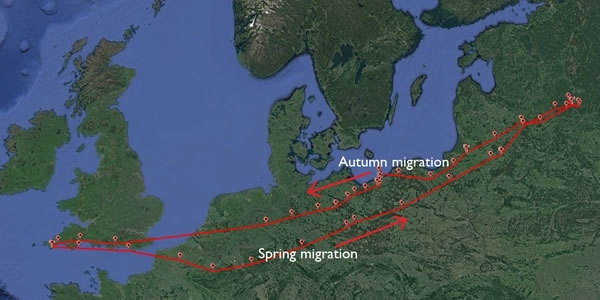
In today’s technological age, ringing is complemented by more sophisticated ways of studying migrant birds. The Woodcock Watch project has used geolocators and satellite tags to shed light on the mammoth spring migrations our migrant woodcock make. This work is now assisted by a new type of tag called a GPS logger.
There are two key advantages of the logger: their accuracy and their efficiency. A geolocator might be accurate to around 50 km, a satellite tag to around 1 km, but GPS loggers can record locations that are accurate up to 5-10 metres. Their battery consumption is low, and whilst they can recharge using a solar-panel, they are much less reliant on sunny weather than the satellite tags. This means they can record data accurately and frequently through Autumn, as well as Spring. Regular followers of the Woodcock Watch project will be aware that this is one of the greatest limitations of the satellite-tags we have used in the past.
The one weakness of the GPS loggers is that they are just that – a logger – not a transmitter. This means they store their data onboard, but unlike our satellite tags, they do not broadcast it via a satellite. To access the data, we must recover the tag by recapturing the bird.
Our Cornish field-site is a perfect place to run a study like this. We have a dedicated annual woodcock catching trip with the sole aim of recapturing ringed birds. This has provided us with a good measure of our recapture rates and maximises the likelihood of recovery.
This year, we deployed 35 GPS loggers which we will be hoping to recover this time next year. On top of this, we also managed to re-catch a woodcock that was tagged with a logger last year. The quality of the data collected, as shown on the map above, should help us answer those final questions that our satellite tags have been unable to.