Key findings
- Light grazing does not affect sediment run-off in drains.
- Drains continue to erode over time.
- Blocking of drains is the only approach to reduce sediment run-off.
Within the current debate about moorland conditions, we revisit an experiment that we undertook nearly 20 years ago to test the effect of upland drains (grips) on water quality. Drainage of heather moorland with open drains (usually called grips) had been a part of moorland management for over 100 years and was promoted by government grant during the 1970s, but by the 1980s, there was anecdotal evidence that these drains caused significant erosion.
To understand this, in 1987 we established a project on Hall Out Moor in Upper Swaledale in the Yorkshire Dales. The vegetation on the site was a predominantly cotton-grass/heather mix, with small areas of bilberry and sphagnum. In August 1987, a contractor using specialist drainage equipment drained an area on a west-facing 7º slope.
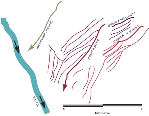
The drains, when first cut, had a typical bottom width of 30 centimetres, a top width of 68 centimetres, a depth of 36 centimetres and side wall angle of 28º, giving a trapezoidal section of total area 1,764 square centimetres. The average spacing between drains was 22 metres. We chose four drains for our study, one drain ‘gripped and grazed’, two drains ‘gripped and not grazed’, and finally a ‘natural’ small stream half a kilometre away on the same slope, which acted as a control site and was also grazed (see Figure 1).
The grazed sites were stocked with Swaledale sheep from 1 May to 31 August each year at a stocking density of one ewe plus lamb at foot to 1.6 hectares. Close to the downstream end of each of the drains we drove a simple vertical plate 90º V-notch weir into the sub-soil such that the base of the V was centrally placed in the drain close the bed of the drain and there was a minimal backwater effect. A metal chute took water and sediment from the V-notch into rectangular collection tanks. The tanks were 180 centimetres long, 120 centimetres wide, 120 centimetres deep and made of marine plywood to give a capacity of 2.72 cubic metres. Within the tanks all sediment fractions coarser than silt were trapped. We monitored and emptied these traps of sediment after significant discharge events between 1987 and 1992.
Between 1991 and 1997, we measured the cross-sectional area of drains at 100- metre intervals down the drains every three months using a profiling frame consisting of 50 vertical steel pins 20 milimetres apart threaded through a bar set horizontally on reference posts driven firmly into the subsoil either side of given cross-sections of the drains. There was no evidence of down-slope variation in changes in drain cross-section between surveys and so data were averaged for each study drain and crosssectional areas calculated. Deposition or erosion along the length of the drains were recorded as a loss or gain in the total cross-sectional area between surveys.
Figure 1: Plan of the drainage network at Hall Out Moor

The sediment loads we collected between 1987 and 1992 (three per year in each drain) were standardised and expressed as kilograms (dry weight) per one-kilometre length of drain. The drained areas had much higher sediment loads than the natural stream (see Table 1). There was no evidence of seasonal trend, suggesting that erosion is event-driven, either by winter or summer storms.
Table 1: Kilogrammes of sediment per kilometre of drain per year, 1987-1992
| Drain |
Sediment (mean kg, ± se) |
| Gripped and grazed |
61.4 (± 8.7) |
| Gripped not grazed |
121.7 (± 44.5) |
| Natural stream |
9.0 (± 6.8) |
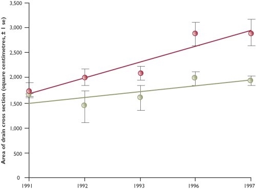
Profile data show that these drains did not stabilise, but continued to erode over at least four years (see Figure 2). After seven years the grips were still eroding. This is in contrast to other upland drains, such as forestry furrows where run-off may be small and which often grass over after a year or so.
We concluded that the natural hillside streams produce negligible sediment even though subject to grazing, but drains continue to erode after cutting. The amount of sediment in the drains was an order of magnitude greater than in the natural stream (control). Drains did not stabilise and erosion was progressive. Thus, where old drainage networks still exist, erosion can only be stopped by blocking them.
Figure 2: Change through time (1991-1997) of the cross-sectional area of the eroded portions of the gripped and grazed, and gripped and not grazed drains
